
I’ve written in the past about the similarities between a true open air Jeep experience and motorcycling.
It turns out we have more in common than that.
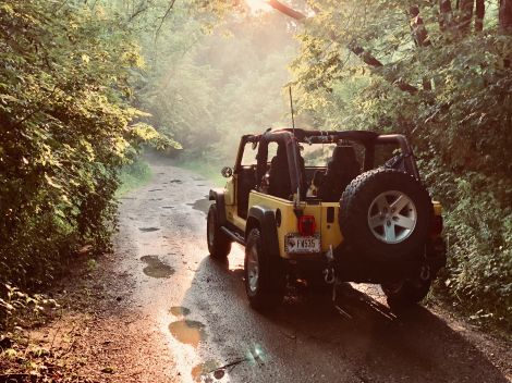
There are several mostly dirt & gravel routes, very long routes, scattered across the country, largely created by motorcyclists. Two-wheelers, I’m grateful for your efforts to keep slow driving interesting.
Most of the GPS routes are freely available, with one notable exception I’ll save for last.
Unfortunately most of them aren’t anywhere remotely close to me, but someday one of my Jeeps will be robust enough, and work will be sane enough, and the pandemic will be quiet enough, that I can try one of these. Maybe.
Ride respectfully
Most of these routes are defined by a non-profit called Backcountry Discovery Routes. They’ve been introducing routes since 2010, and their website is a great resource: not only the routes, but updates, alternate routes to bypass more technical segments, camping and hotel information, etc. Mad props.
Much like the Jeep world has embraced (well, somewhat embraced) Tread Lightly, the BDR organization promotes their “ride respectfully” ethic.
East of the Mississippi
When it comes to off-roading, back-roading, dispersed camping, and backpacking, there are really two very different worlds in the U.S. The mostly urban, mostly private land in the states east of the Mississippi have very different rules than the vast swathes of federal land in the mountain states.
Still, gravel and dirt roads can be found in the east if you look hard enough (and trust me, I keep looking).
Northeast
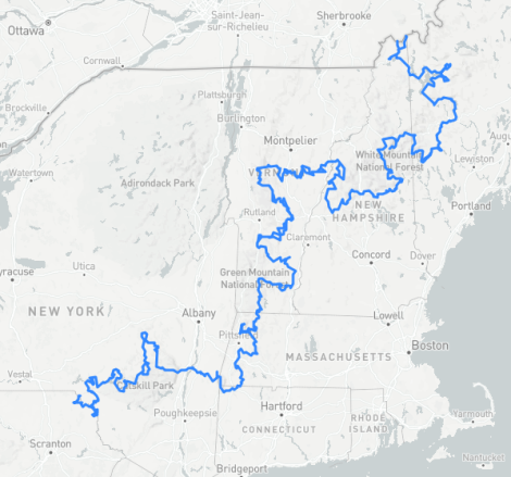
This is one of BDR’s routes. One end is the impregnable Canadian border; the other is a small town named Hancock, New York. 1300 miles, seven states, several technical sections with alternatives for the less ambitious, some roads that are only open for part of the year.
Estimated riding time: 8 days
Mid-atlantic
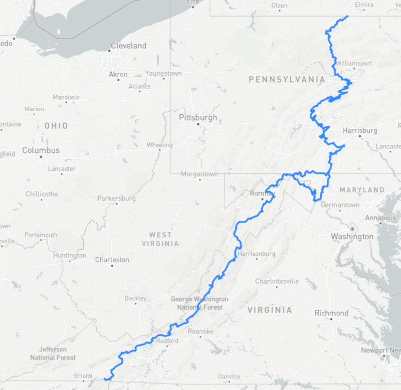
Another BDR special. This isn’t your favorite apostle’s road to Damascus.
Damascus, Virginia, with a quick dip into Tennessee, then all the way to the Pennsylvania/New York state line. A mere 1000 miles, this route starts at a waterfall and includes a visit to Antietam National Cemetery (https://www.nps.gov/anti/learn/historyculture/antietam-national-cemetery.htm), honoring one of the most brutal days of a thoroughly brutal war.
Estimated riding time: 9 days
Kentucky Adventure Tour
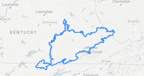
Growing up in Indiana, there were no shortage of Kentucky jokes. Sadly my cousin married a Kentucky sheriff, so I’ve had to learn to smile and play nice with our southern neighbors.
The state, regardless of what you may think of its inhabitants (they’re great people, really) is spectacular. Rolling hills, valleys, curvy roads, mountains (ok, Appalachian mountains, but I’ll take what I can get around here), lakes, rivers...just beautiful.
This loop covers 900 miles without the harder segments (and trust me, from what I’ve seen of eastern Kentucky, there are some brutal forest roads), and crosses the West Virginian, Virginian, and Tennessee state lines just to add some exotic flair.
Just be careful of people who don’t much like noisy vehicles coming through their peaceful backwaters; in fact, that’s a problem for all of these routes. (Again, see “ride respectfully” above.)
Estimated riding time: 6 days
Trans Wisconsin Adventure Trail
http://transwisconsintrail.com
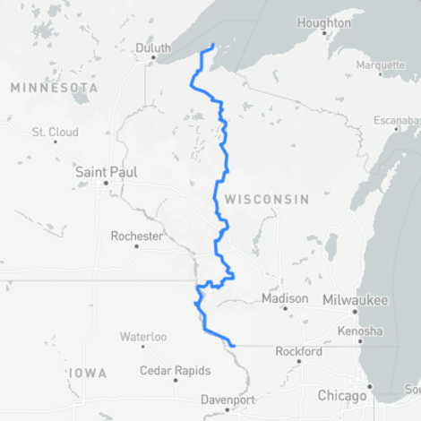
The website sums it up this way:
Be prepared for DEEP sand, ruts, mud, dust, livestock in the road, horse and cow manure, deer, bears, porcupines, possums, turkeys, logs, low hanging branches, barbed wire, drunk or distracted drivers, bear hunters running dogs, logging trucks, ATV’s, rednecks, amish, bad roads, no roads, lakes, streams, washouts, police, sharp unmarked corners, etc. Be aware you can die at any point along this route, regardless of your skill level.
600+ miles for the Overland version of the trail. Guided tours available (which seems like a pretty cool way to find a group of riders to share the risks with if you’re not from the area).
West of the Mississippi
Oklahoma Adventure Trail
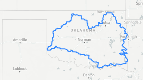
This route doesn’t have a dedicated website; instead, there’s a forum thread and a tourism site page. If anyone knows of something more official, please share it in the comments and I’ll update this post.
- https://advrider.com/f/threads/making-of-the-oklahoma-adventure-trail.836706/
- https://www.travelok.com/listings/view.profile/id.24524
1500 miles of pure Oklahoma, with one optional side route to take you across the Red River into Texas. I’m sure Oklahoma can’t be as boring as, say, Kansas, right?
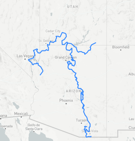
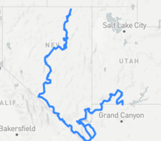
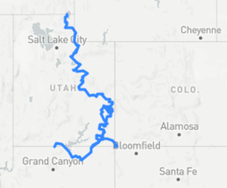
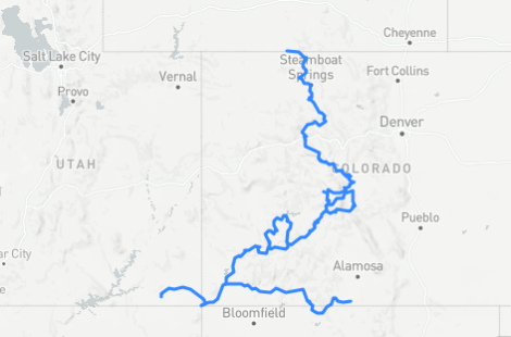
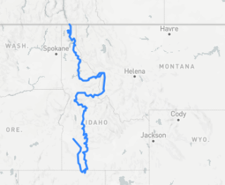
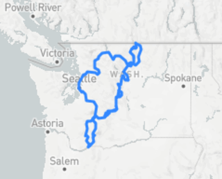
The western BDR routes
The Backcountry Discovery Routes organization has defined several adventure trails in the mountain states along with connecting routes. Rather than try to describe a part of the country I know nothing about, I’m going to be lazy and just link you to the BDR site again and show you the maps.
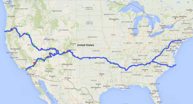
Trans-America Trail
No, not the Pan-American Highway; although that would be fun, it also requires far more physical endurance than I will ever possess again in this lifetime.
This coast-to-coast mostly-unpaved route was shepherded into existence by Sam Correro, originally from Tennessee to Oregon, and the “official” route can only be purchased from Sam. There are now some community-managed versions, although there’s some controversy over private lands along the way; if I ever have the ambition to drive it, I’ll gladly pay Sam for the hard work he’s done.
I can barely manage to keep straight the routes I’ve found in Indiana with GPS and mobile apps; mapping the gravel and dirt roads across the country in 1984? The dude worked for it.
Because I don’t have the GPS file(s), this is a representation of the map I found at https://worldcrosser.com/trans-america-trail/
Epilogue: For the unpowered two-wheelers
Thanks to Wikipedia, I discovered this organization for bicyclists with backroads routes across the country:
No matter your vehicle of choice: go forth, ride safely, and coëxist peacefully.