
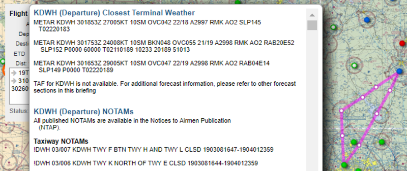
Day three is a bust. I planned my next required cross-country flight, but the weather isn’t cooperating. There was a chance for thunderstorms this afternoon, so I adjusted my schedule to fly this morning. Unfortunately, the clouds were hanging low. I could have gone scud running, but that’s a good way to get killed.
I’ve never been one to pay attention to weather. I always just looked out the window or maybe opened the door to check the temperature. Now I find myself poring over the weather just to figure out whether or not I can fly. Where do I get my weather information? I’m so glad you asked!
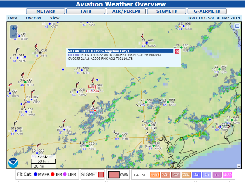
Weather data is captured from a variety of sources, from automatic weather stations to manual observations and pilot reports. I grab mine from aviationweather.gov, an official source of weather from NOAA. The box in the screencap shows the current conditions at my destination airport. That gobbledygook actually means something! Let’s break it down.
Data at: 1854 UTC 30 Mar 2019
KLFK 301802Z AUTO 23005KT 10SM SCT026 BKN043 OVC055 21/18 A2996 RMK AO2 T02110178
The first line gives the time in military notation, referenced to Mean Greenwich Time (UTC). When I clicked on it, the time was 18:54 which is 6:54 UTC. That has to be translated back to my local time zone which is Central Daylight Savings Time (CDT). I do that by subtracting five hours, giving me 1:54 CDT which is 13:54 CDT in military time. The next bit is easy enough. It’s March 30th. That gets a little complicated when the date rolls over. It will be tomorrow in UTC when it’s still today in CDT.
The next line is where things get complicated. KLFK is the airport code for Lufkin/Angelina County airport. The next item is the date at time of the report: 30th day at 18:02 Zulu (UTC) time. AUTO tells me it’s from an automatic weather station. The wind is coming out of the southwest (230) at 5 knots (05KT) or 5.75 mph.
10SM means that the visibility is 10 miles. Those are statute miles. It’s only 8.7 nautical miles which is what the gauges reference in older airplanes.
SCT026 means there are scattered clouds at 2,600 ft. BKN043 means broken clouds at 4,300 feet. OVC055 means overcast clouds at 5,500 feet. As a student pilot, my current endorsement requires a minimum cloud ceiling of 3,000 feet. While I probably could go right now, it would mean flying fairly low which also means it would be a bumpy ride. Not exactly a fun day of flying.
The 21/18 is the temperature and dewpoint in degrees celcius. These give me an idea of potential icing conditions. The current barometric pressure is shown by the next item, A2996. This indicates the pressure is 29.96 mm of Hg. The altimeter uses pressure to determine how high the plane is off the ground, so it has to be adjusted to reflect the local conditions. It’s dangerous to fly from an area of high pressure to low pressure without adjusting the altimeter. Without adjustment, the altimeter will indicate the plane is flying higher than it really is.
The next section, RMK A02, is a remark about the station. I’ll be honest here, that’s something that I have to lookup. Don’t judge me. There are over 50 codes. In this case, it means “Station automated with a rain/snow precip. sensor.” The last element is a repeat of the temperature and dew point tied to the remark.
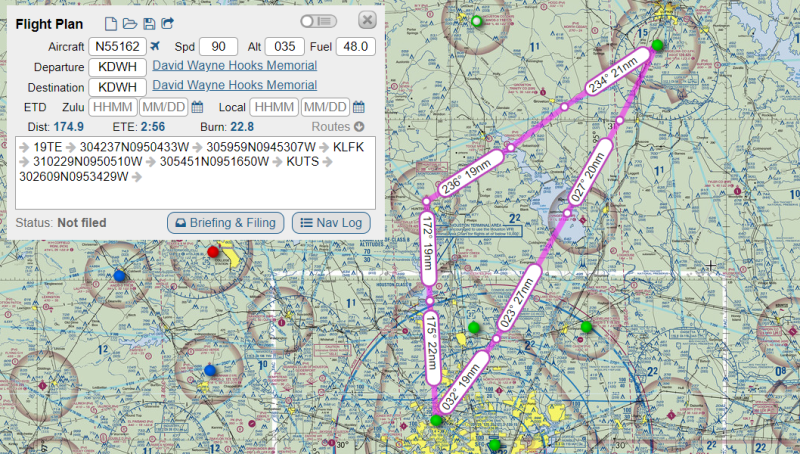
There are sites which will convert the reports into more conversational language. Even AviationWeather will give a decoded version. Pilots should be able to decode it in their heads because automated weather briefings are provided in coded format. Here’s what a briefing looks like in the planning software.
So, that’s it! I’m CERTAIN that I lost most of Oppo after the first paragraph, so thanks for sticking around if you made it this far!